NEW WARNING FOR FLASH FLOODS
Impact Based Warnings (IBW) for Flash Floods
Each Flash Flood Warning (FFW) will contain a bulleted format of easily readable in formation describing the flood flash, the source of the information (e.g., radar, gauge, trained spotter, Emergency Manager), and a brief description of the impact of the flash flood. It will also include machine readable tags to characterize the flash flood damage threat, source information, and causative event.
WEAs will be limited to only those FFWs with the damage threat tags of “Considerable” or “Catastrophic.” T hird party vendors will be able to identify and extract the “emergency” language in the FFWs.
With this change to impact based FFWs, the NWS is aiming to improve the public response to Flash Flood Warnings by providing easily readable information and issuing WEA alerts only for flash flood events that require immediate life saving action.
What is WEA?
Impact-based warnings contain hazard, source, and impact information, and additional damage threat tags. On the right is a sample impact-based warning.
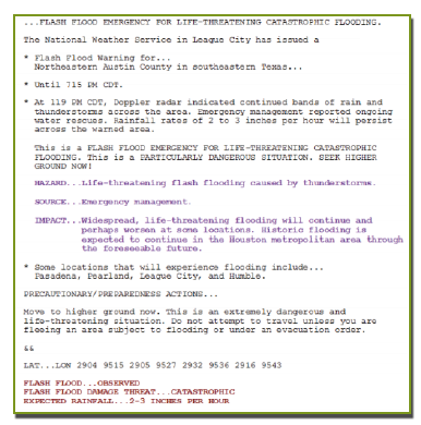
Hazard, Source, and Impact Information
Each Flash Flood Warning (FFW) will contain individual lines that clearly state hazard, source, and impact information.
Tags
Tags will appear at the bottom of FFWs and in Flash Flood Satements (FFSs), which provide supplemental information on active FFWs.
Flash Flood Damage Threat Tag
|
Explanation
|
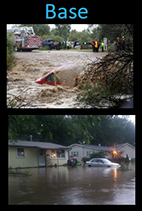
| "Base" (No Tag) |
Use most of the time, when flash flood impact damage is possiible. |
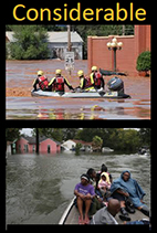
| FLASH FLOOD DAMAGE THREAT... CONSIDERABLE* |
Use rarely, when there are indications flash flooding capable of unusual severity of impact is imminent or ongoing and urgent action is needed to protect lives and property. |
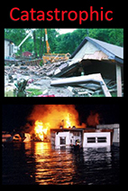
| FLASH FLOOD DAMAGE THREAT... CATASTROPHIC*+ |
Use exceedingly rarely, when a flash flood threat to life and catastrophic damage is occurring or is imminent, and floodwaters have risen or will rise to levels rarely if ever seen. |
| Flash Flooding Source !Information Tag |
Explanation |
| FLASH FLOOD... RADAR INDICATED |
Evidence on radar and near storm environment is supportive, but no confirmation. |
| FLASH FLOOD... OBSERVED |
Flash flood impacts confirmed by trained spotters, law enforcement, media, other credible human observers, etc. |
| Flash Flooding Causative Event Tag |
Explanation |
| EXPECTED RAINFALL ... [##-4H INCHES PER HOUR], [##-ii INCHES IN #i MINUTES], [## INCHES IN ## MINUTES] |
Use to identify rainfall rate leading to potential or observed flash flooding, including rain falling on a burn scar. |
| [DAM or LEVEE] FAILURE ... [IMMINENT or OCCURING] |
Use to provide additional information about the status of the failing dam or levee, whether it is "imminent" or "occurring". |
NOTE: The colors in the left column do not translate to the actual product and are only meant for visualization purposes in this presentation or associated internal/external outreach.
* Category utilized for a Wireless Emergency Alert (WEA).
+ Catastrophic equates to a headline and additional language for a "Flash Flood Emergency".
Flash Flood Warning Tags Base (No WEA Alert)
Roads:
- Multiple city streets or maintained county/state roads closed or impassable due to standing or flowing water in areas that are not usual low water collection points (ie intersections, roads without permanent low water crossing signs)
- Approximately 6 inches or more of flowing water is over a road or bridge from a swollen river or creek (6 inches = ankle deep).
- Two to Three feet or more of standing water that poses a threat to life or property (ie, three or more feet of water on a roadway).
Buildings / Structures / Other:
- Any amount of water in contact with, flowing into, or causing damage to the first floor of a residence or public building as a result of excessive runoff. Basements only if in multiple homes (10 or more for example) or water is flowing from a creek or stream.
- Mudslide or landslide occurring within 6 hours of heavy rain event
- Major ice jam flooding.
Rescues / Evacuations:
- Person or vehicle is swept away by flowing water from runoff.
Flash Flood Warning Tag Considerable (WEA Alerted!)
- Extreme and Rare Event
- High impact especially in atypical flood location
- Water rescues performed because people are unable to get out of the way of the rising water. Not based on vehicles driving into flood waters.
- Evacuations required due to rapidly rising water into first floor of residences.
- Risk of fatalities significantly increased, urgent action needed to protect life and property
Flash Flood Warning Tag Catastrophic (WEA Alerted!)
Significant, widespread damage with a high likelihood of numerous fatalities is expected.
- Flash Flood Emergency!!
- Generational type event
- High Risk Dam Break